The Waorani people live in the heart of the Ecuadorian Amazon. Five years ago they started to make a territory map, part of a strategy to defend their lands, all the material and non-material resources that live within it, and the futures of their children from the impacts of new oil developments. The Waorani mapping team, working with Alianza Ceibo and Amazon Frontlines, tried a variety of existing mapping applications, but none of these were a good fit for the offline environment and highly collaborative workflow the Waorani villagers demanded. They partnered with Digital Democracy in the early stages of Mapeo development, and have been using Mapeo and contributing to its design since 2015.
The Waorani mapping process:
- The Waorani mapping team holds a preliminary workshop in each village to agree the conditions and methods of the mapping.
- The community draws detailed territory maps with everybody participating; elders often sit to the side and indicate to others how to draw different rivers, their names and where resources and places of importance are located. Sometimes men and women draw maps in separate groups to ensure gendered perceptions of territory are.
- The Waorani team holds a training workshop in each village to teach community technicians the basics of GIS and how to use a GPS.
- The community mapping teams go out on walks with villages elders and knowledge holders to collect GIS information of all the places and resources the community wants to map, such as palm swamps, fruiting trees, animal mineral licks and fishing spots, and groundtruth the data shown on the hand-drawn maps.
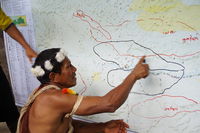
- Back in the village, the team enters all the GPS points into Mapeo, adding in stories and explanations about places, including Waorani history, cultural and ethnobotanical information. They use a variety of background maps from satellite analyses that show elevation, river-basins and forest cover to help draw and locate some of the geographical features.
- The Waorani maps use symbols drawn by the mapping team, and they have a legend made up of over 150 different items, from jaguar paths to clay deposits, ancient burial sites to flying ants nests. The data is exported from Mapeo to geojson, and then uploaded into Mapbox where the design of the map is stored, and then each community’s area is exported and a legend and titles added in illustrator. Draft maps are returned to each village for verification, and then final maps are printed and given to each village, and each family in each village.
- The Waorani team, with support from Digital Democracy also built a variety of online, interactive and print resources to support the legal case they took against the Ecuadorian Government for creating a new oil block without following a proper free, prior and informed consultation process. The Waorani won this lawsuit in April 2019, creating an huge precedent in Ecuador and internationally. Maps showing which communities would be affected by the oil explorations, and how they would be impacted, were an important part of the case.
At the end of 2018 the Waorani team had made maps with 18 out of 52 villages, and in 2019 is focusing on the legal campaign to keep the Pastaza area free of oil and deepening the storytelling nature of the maps by adding more layers of cultural and historical information. The mapping work has brought a huge amount of territorial information to light, facilitating dialogue between older and younger generations who, due to current schooling methods, no longer spend the time together in the forest that they used to. The mapping has also created a space for communities to discuss the impacts of living in settled communities, and has built solidarity between communities on common threats to territory and built unity to defend it.